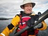
Monica and I went to Cadboro bay to try out a CD slipstream. There was a little bit of wind chop and we did a quick run around the bay to see if Monica liked the feel of it. The jury is still out…
3 km, 1.5 NM, YTD: 458 km
Monica and I went to Cadboro bay to try out a CD slipstream. There was a little bit of wind chop and we did a quick run around the bay to see if Monica liked the feel of it. The jury is still out…
3 km, 1.5 NM, YTD: 458 km
George, Dan, Gordin, John, Hans and I set out from Amherst to paddle around Sidney Island. Conditions were gentle and we made good time going down the east side of Sidney. We stopped for a very relaxed lunch by Hamley Point and then wended our way back up the west side of Sidney. All in all a beautiful day’s paddle!
27 Km, 14.5 NM, YTD: 455 km. 
 boats on the beach at lunch
  Conglomerate outcrop
 Siesta time for John?
http://maps.google.com/maps?f=q&hl=en&geocode=&q=48.6015,-123.2698&ie=UTF8&z=12&om=1
On Friday Morning, Hans, John and I set out from Roberts Bay to paddle our way up to Blackberry Point to join some others camping there. We had a stiff breeze in our faces until lunch time, but made a good day of it overall, finishing at Chivers Point on Wallace Island. Other than the morning wind, the weather was superb. Wallace is a beautiful spot!
On Saturday morning we set out at around 9 and made our way to Blackberry Point (another 14 km), where we met Paolo, George, Gerry, Tony, Lynn, Peter and Debbie, and set up camp. Several of us paddled up to Gabriola Passage for the afternoon, admiring magnificent cliffs, peregrine falcons and much more. We came back to Blackberry for a wonderful evening. George left after dinner to head home.
On Sunday, Paolo and I set off towards the De Courcy Group where we joined up with Lynn and Peter for a paddle along the shores of Pylades, Ruxton and De Courcy Islands. In spite of what is indicated on the charts, there is no passage between Link and De Courcy at low tide! A short portage was in order! After returning to camp, I loaded my boat and set off for Cufra inlet on Thetis Island. On my way I had to be a rascal and do a short detour around the ragged rocks! I also celebrated making 100 km on the trip. In Cufra Inlet I stayed with Bob and Joan where I had a magnificent dinner and a very pleasant night in a bed! I ended up leaving my kayak “moored” to the dock for the night – it felt strange not to beach my boat but it was very handy the next morning.
On Monday I set out on my own from Bob and Joan’s at 8 AM after a hearty breakfast and went around the west side of Thetis and Kuper Islands. I made a short stop on Tent Island where I made arrangements with Monica for a pick up at Maple Bay at 1:30. I ended up being 1 minute late – which I can blame on the stiff breeze I encountered in Stuart Channel on my way to Grave Point. There are a couple of possible camp sites along this stretch, though a plastic boat would help!
All in all it was a wonderful weekend, kayaking, friends, great weather, good food, wildlife and more. I have an interactive google maps link to the trip route at: http://www.islandnet.com/~mjackson/google/gulf_islands2.htm
I thought I would estimate how much stuff I brought along by weighing it all when I got back. Excluding water and the food I brought, I had 125 lbs of gear in my boat! The food and water would have added at least another 30 lbs..
Some photos posted at: http://picasaweb.google.ca/mhjackson123/GulfIslandsMay2008
133 km, 72 NM, YTD: 428 km 
http://maps.google.com/maps?f=q&hl=en&geocode=&q=49.0053,-123.6787&ie=UTF8&z=12&om=1
http://maps.google.com/maps?f=q&hl=en&geocode=&q=49.0553,-123.6567&ie=UTF8&z=12&om=1
http://maps.google.com/maps?f=q&hl=en&geocode=&q=48.9553,-123.5732&ie=UTF8&z=12&om=1
Dan, John, George and I set out from Amherst to paddle to Portland where Alan and Greg were camping. Conditions were beautiful and calm and there was only a small current against us. Dorothea and Mike also arrived for lunch at Arbutus point. We paddled back to Amherst with Mike and Dorothea. (BTW the GPS was working again today – not sure what the problem was…)
20.5 km, 11 NM, YTD: 295 km.  the usual track shot
 a bigger view
Dan, George, Gordin and I all set out from Tudor Avenue beach for a fairly early morning paddle around Chatham. Conditions were very nice and gentle, little wind and little current and some light rain. My GPS stopped working at the start of the trip, so I have no recorded track, though I have a rough track from memory. Another nice day on the water!
10 Km, 6NM, YTD 275