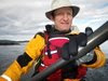
I went for a quick paddle around the bay after work to clear some cobwebs. There was a brisk wind out of the SE and the F1 performed well. I noticed some pretty good waves at Cadboro Point in the distance.
 |
the usual screenshot - google hybrid - click to enlarge
|
I tried some other map options using GPS Visualizer as well as the internet maps feature in Oziexplorer... they all have their pros and cons...
 |
| GPSViz - Open Street Map - click to enlarge |
 |
| GPSViz - Yahoo Hybrid - click to enlarge |
 |
| Ozi - Virtual earth map - click to enlarge |
 |
| Ozi- Highest detail of virtual earth - click to enlarge |
 |
| Oziexplorer highest detail chart - click to enlarge |
 |
| Ozi- Race Rocks to d'Arcy Chart - click to enlarge |
5 km, YTD 17 km


No comments:
Post a Comment